
According to many visitor polls, Gower beaches are among the finest to visit – not just in Wales or Britain, but Europe and, indeed the world. There are around twenty Gower peninsula beaches in all, mainly found on the southern and western coasts of this small area to the west of the city of Swansea, which was declared the UK’s first Area of Outstanding Natural Beauty in 1956. The Gower coast is wonderfully varied, from popular holiday resort beaches on the outskirts of Swansea to wild, remote, rocky beaches only accessible on foot, and from tiny coves to vast beaches miles long. Rhossili Bay, Three Cliffs Bay and Oxwich Bay are the three that get most of the plaudits, but Gower has so many more beaches that deserve to be discovered. Here is our ultimate Gower beaches guide.
Contents
Swansea Bay Beach
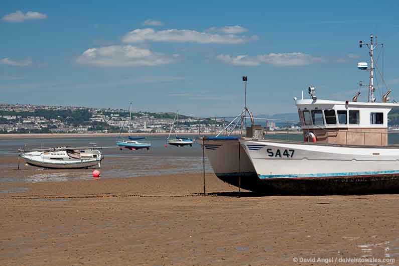
Swansea Bay Beach stretches the four miles from the Marina and Maritime Quarter of Swansea to the landmark islets and lighthouse of Mumbles Head. It is an enormous expanse of sand, and at low tide the sea retreats a long way out, revealing a lot of wet sand, rockpools and, eventually, mud.
The beach is at its most attractive at the city end, although there is still good quality sand as far west as the suburb of Blackpill.
Mumbles – also known as Oystermouth – is considered Swansea’s seaside suburb, but it doesn’t have the best of the beach. It either consists of large stones and pebbles interspersed with rockpools, or wet sand and pools of water. It’s fine for a wander out to the fishing boats for a while, and our three-year-old would love finding what lurks in the many rockpools, as he would the ice cream kiosk next to Verdi’s. As you head down towards the Pier,
Mumbles is well-known for the ‘Mumbles Mile’ pub crawl, but we’ve tended to spend more time along the seafront and exploring beyond. After Verdi’s you reach Mumbles Pier, with its red dragon beckoning visitors to explore. The Pier and amusement arcade has a real yesteryear feel about it, all very traditional old British seaside fare. It has been renovated in the last few years, and the lifeboat station at the end has been rebuilt. It’s well worth the small fee to enter to get a better view of Mumbles lighthouse, which is just around the corner.
Bracelet Bay

It’s a short climb up a flight of stone steps from the Pier to Mumbles Road, and from here you can either climb the hill immediately on your left for a closer look at the lighthouse, or continue along the road until you reach the car park for Bracelet Bay.
Bracelet Bay is a great beach, with something for many: some fine stretches of sand, plenty of rockpools for the curious to explore, and a brilliant backdrop, in the form of Mumbles lighthouse. There’s also a kiosk at one end of the beach and an Italian restaurant at the other.
Limeslade Bay

Limeslade Bay is a tiny beach just beyond Bracelet Bay, probably only twenty or so metres wide at its narrowest point. It’s mainly rocky and pebbly, with a few sandy patches.
Langland Bay
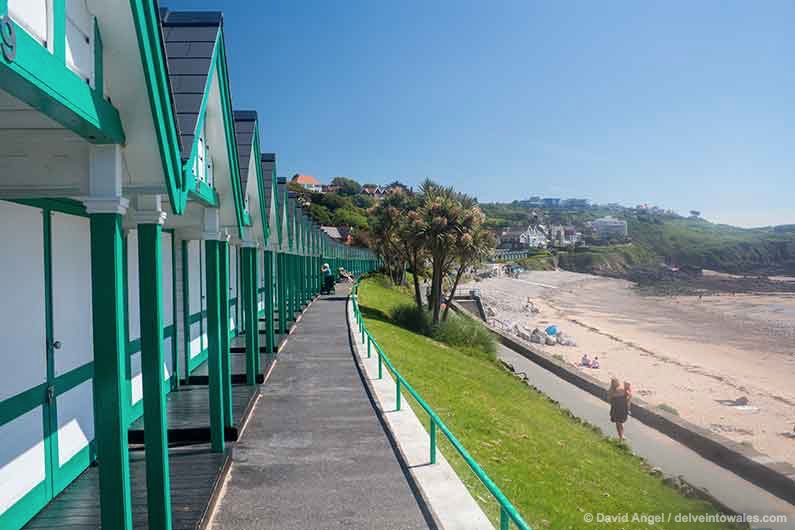
If you approach by the coast path, a huge open beach opens out before you, mostly sand with a few rockpools exposed at low tide, and a row of bright green and white beach huts along the promenade. Most of the beach is Langland Bay, but the first corner you reach is known as Rotherslade Bay, overlooked by a cluster of beach huts and a takeaway kiosk. At high tide, the two beaches are separated by rocks.
Langland is a short walk over the hill from Mumbles, so is very much a city beach, and my favourite among them. It has been popular since the 19th century, when the Crawshay family who owned the Merthyr Tydfil Ironworks, built themselves a grand holiday home behind the beach huts – it has been converted into luxury apartments.
Langland always draws plenty of visitors in the spring and summer months – mainly to relax on the beach, at the cafes or takeaway, but also to surf.
Caswell Bay
Like Langland, Caswell is a real family favourite, with all the facilities you need for a great day out with the kids, with two beachside cafes and a shop for food and supplies. You’ll often find it packed with holidaymakers in the summer holidays, but it’s also a great place to come in the off season – it’s a great place to come for a bracing winter walk and to breathe in that cool, fresh sea air.
It’s the last of the Swansea suburban beaches – after Caswell, the coast path takes you to two quiet beaches, and out into open countryside.
Brandy Cove
Brandy Cove is only a few minutes’ walk from Caswell Bay, but seems a world away, a tiny rocky cove with a small patch of sand, far removed from the bustle of its much bigger, better-known neighbour.
Pwlldu Bay
The second secluded beach in a mile, Pwlldu (meaning ‘black pool’, but don’t expect towers or illuminations here) is a lovely discovery, reached either along the coast path from Bishopston village, or by a walk through the lush green Bishopston Valley, which follows almost the entire course of a stream through peaceful woodland before emerging into a field just behind the beach.
The beach is a bank of pebbles at high tide, the sand gradually revealed as the tide ebbs away.
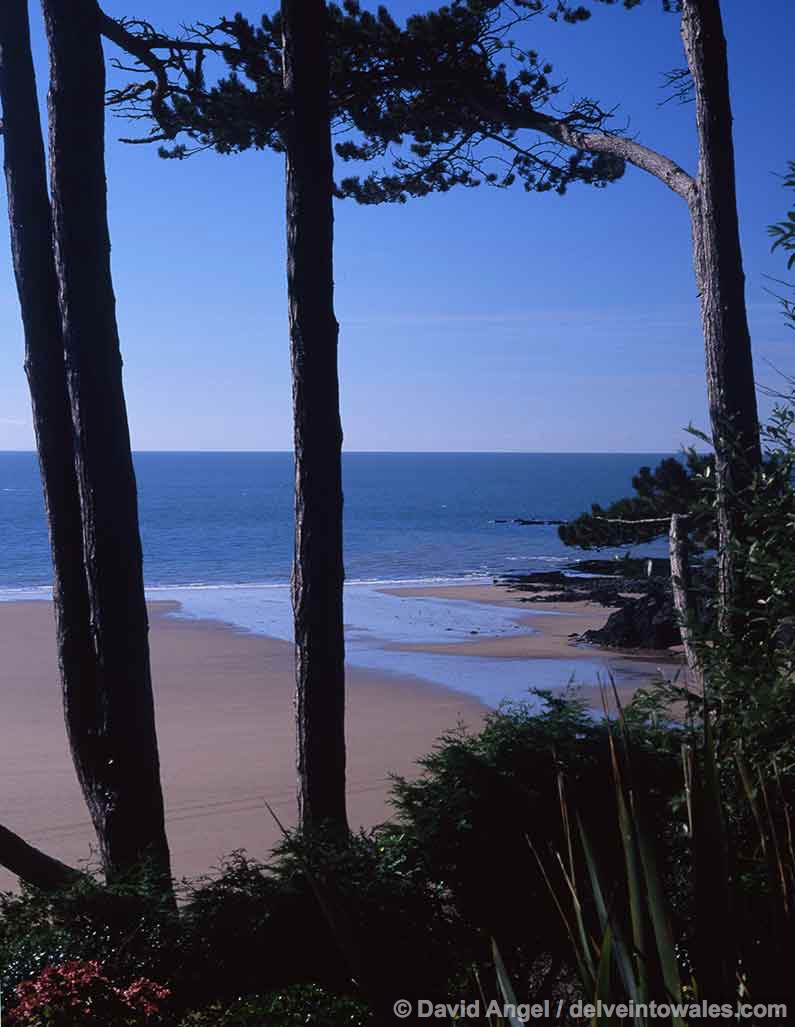
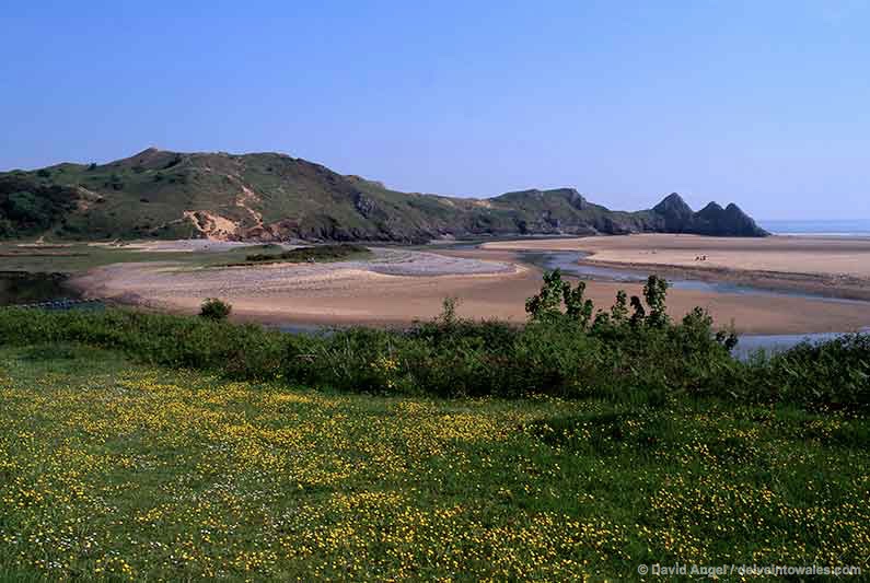
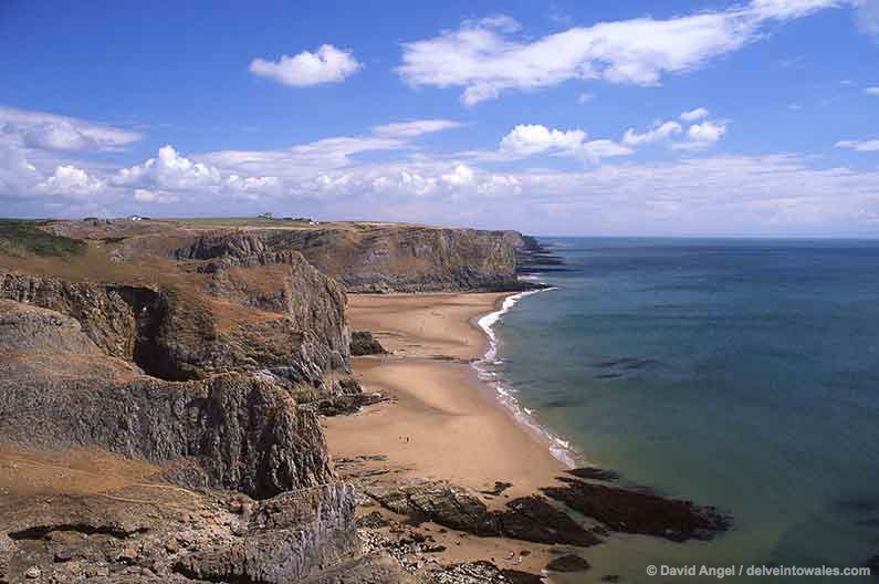
Three Cliffs Bay
Three Cliffs Bay is one of those places that blows me away, no matter how many times I have been there – and there have been many.
As with some other Gower beaches, a combination of its geography, natural seclusion and lack of development have managed to preserve it as it has always been – a hidden coastal Arcadia, tucked away in a secret valley. A stream, Pennard Pill, has over millennia carved a deep valley between two banks of sand dune, meandering its last mile or so to the sea across a broad, beautiful stretch of sand, with a romantic, crumbling castle ruin overlooking the serene scene. A long finger of land points down into the sand, culminating in the picturesque three small cliffs that give the bay and beach its name. The beach stretches away in both directions from the estuary of the Pill, to neighbouring Pobbles Bay to the east and towards Tor Bay and Oxwich to the west.

There are four ways to get to Three Cliffs Bay, and all of them involve a walk. The quickest is from Penmaen, to the west of the Bay, a short downhill route. There’s a flatter path through the woods from the village of Parkmill, on the main A4118 road, which climbs up towards Pennard Castle before descending the dunes to the beach. There’s also the coast path route from the east, beginning at the village of Southgate. The number 14 bus runs there (the listed destination is Pennard Cliffs) from Swansea. This walk takes longer than the other options – 20 to 25 minutes – ending in an epic descent of the dunes.
The other option is if you stay in the one place you can next to the beach, Three Cliffs Bay Caravan Park. It’s only a short walk down from there to the west side of the beach, and at low tide you can cross to the other side of the stream on stepping stones. The other Three Cliffs Bay accommodation is further afield. Parc Le Breos House is the closest, a Victorian hunting lodge in the grounds of a medieval deer park, about two miles away from the beach, while Oxwich Bay Hotel is about four miles to the west.
Tor Bay
Tor Bay is essentially a continuation of Three Cliffs, and it’s the section beyond Great Tor headland, which is prominent as you look west from the dunes above Three Cliffs.
It’s most easily reached from the small car park in the village of Penmaen, which you reach by climbing the hill from the bottom of the valley at Parkmill, and turning left near the top. You then follow the coastal path – it’s worth taking the detour around Penmaen Burrows, at the top of the headland. Tor Bay is only a short walk down from there. Bring everything you need with you and enjoy the outstanding scenery.
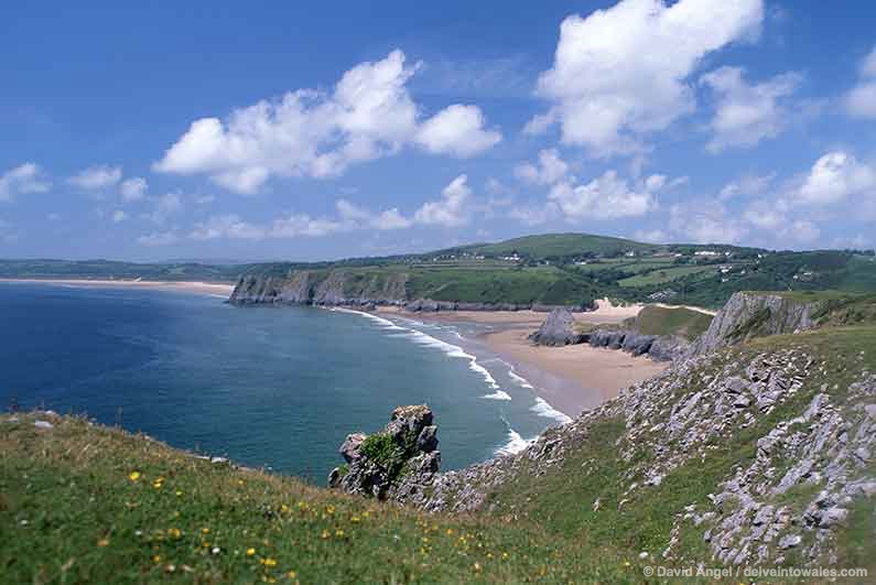
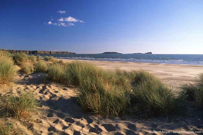
Oxwich Bay
Beyond Three Cliffs and Tor Bay, the sand arcs away for miles towards the horizon, culminating in a wooded headland. This is the wondrous Oxwich Bay.
The eastern part of the beach is also often referred to as Nicholaston Burrows, but this is really the area behind it, a wild warren of sand dunes that is home to pyramidal orchids and rare lichens. The car park is around a twenty-minute walk from the beach, so when you reach the sand you’ll be rewarded with acres of it to yourself. The whole bay also regularly appears in ‘top beaches’ lists, which, when you see it for yourself, is no surprise at all.
The western end of Oxwich beach, close to Oxwich village, is much busier. The car park is only a short walk from the end of the beach, and after passing some dunes you walk out onto the glorious sand, with a sublime view stretching back to Three Cliffs and the east Gower coast. The Oxwich Bay Hotel also surveys the scene from this end of the beach.
It’s also worth taking the time to explore the village and area around, including the grand Tudor-period manor house that goes by the name of Oxwich Castle, and the tiny lime-washed church of St Illtyd hidden on the wooded headland at the west end of the beach.
Port Eynon Beach
The first Gower beach I was ever taken to as a child was Port Eynon, and I have many fond memories of the place. It’s a long, seemingly endless sweep of sand that begins close to Port Eynon Point headland and continues all the way around to the nearby village of Horton, which is the name some give to the eastern end of the beach.
After some of the journeys involved to reach some Gower beaches, Port Eynon is positively user-friendly, and nearly always wins Blue Flag accreditation partly because of its ease of access. After all the windswept wilderness and worthy walking along miles of coastal paths, sometimes it’s nice to sit down and have a bag of chips. And an ice cream.
Port Eynon is special because it has those things very close to the beach, and everything you could want for a great family day out, but you’re also only a few minutes away from the starting point of what we think is one of the best coastal walks in the UK – the Port Eynon to Rhossili walk.
And if you’re on a budget, the Port Eynon youth hostel is a fantastic place to stay with great views over the beach.
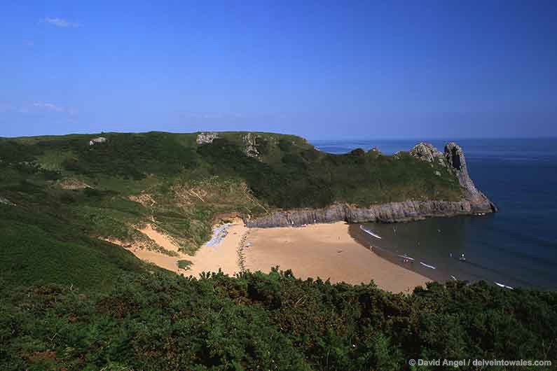
Mewslade Bay
From above, at high tide, there is no trace of Mewslade Bay’s beach, just an imposing line of cliffs, with jagged rock pinnacles and aretes jutting out of the frothing sea. But once the tide retreats, one of the most wonderful beaches in Wales reveals itself.
Reaching Mewslade Bay involves a bit of a walk – the closest car park is almost a mile away on the B4247 road down to Rhossili and you soon reach the narrow valley leading to the beach. At the end of the path, you have to walk between some rocks before emerging onto the sand.
One of the joys of visiting Mewslade Bay is that you feel like you’re one of the first people to discover the beach. In all the times I’ve stopped by there, even in glorious summer weather, you always have acres of empty beach to explore for yourself. You’ll always see a few sun worshippers, beachcombers and dog walkers along the way, but its relatively remote location means that relatively few make the journey there. Mewslade is an outstanding beach, and one I can’t wait to revisit.
Fall Bay

You can understand why Mewslade has remained a hidden gem for so long, but Fall Bay is a more puzzling one. It’s still a bit of a hike from Rhossili – about 15-20 minutes if you follow the path through the fields from the main car park, or 25-30 minutes if you follow the track and path along the coast as far as the Tears Point headland. But it’s much closer to Rhossili than Mewslade. And yet….
The approach along the coast path from Rhossili is more rewarding than the short cut across the fields. You follow the path along the large drystone walls enclosing Rhossili’s medieval strip-field system, known locally as the Vile, and a long sweep of cliffs and coves reveals itself. Three or four boats are tied to rocks just above the rocky shoreline to the south, and a series of wave-cut rock platforms leads the eye to this exquisite little beach, backed by two high cliffs.
It’s always quiet here. A few inquisitive souls will have made their way there, and together you can savour this awe-inspiring spot.
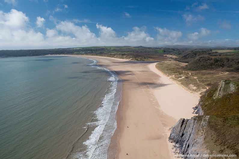
Rhossili Bay
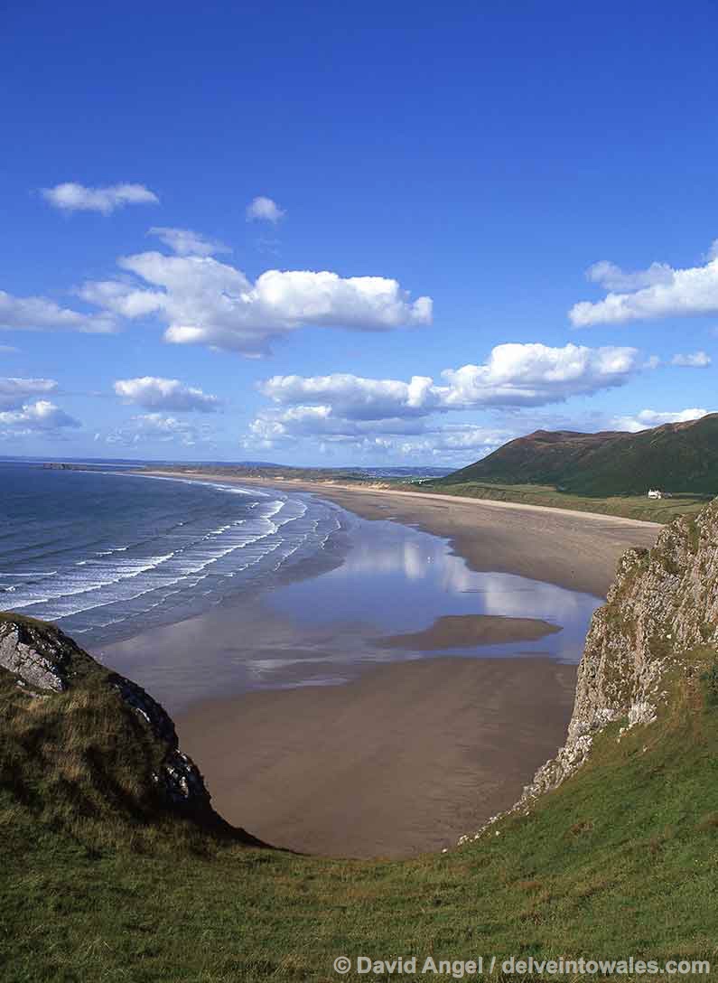
Rhossili beach has had many an accolade in its time. Best beach in Britain. Best beach in Europe. Third best beach in the world. One of the top ten places in the world to see a sunset. This is the reason why so few make it to the lesser-known beaches along the coast. If you have limited time, this is where you’ll want to spend it: gazing out over, walking along or lying back and sun-snoozing on one of the best beaches on the planet.
I vividly remember the first time I visited Rhossili beach, when I was nine years old, staggered that we had never been there before, and insisting afterwards that we never need visit another beach again.
On one of our most recent visits, we took the 118 bus from Swansea to Rhossili, along with a group of about 12 Chinese students. As you approach the village, you catch fleeting, tantalising glimpses of the coast above the hedgerows. The students were craning their necks, eager to see every detail. Soon after the bus enters the village, you see the beach for the first time. I’ll never forget the collective “Aaahhhhh!” from the students as they saw it. I felt the same inside, as I had done many times before. They began asking us how to get down to the beach and we showed them, also telling them where to shoot their photos.
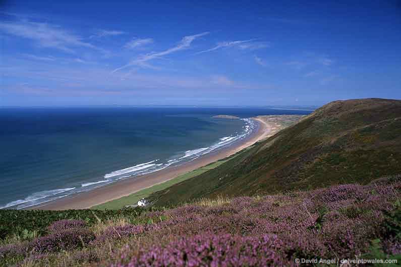
Rhossili village sits on top of 250-foot-high cliffs, and the only way down to the beach is via a steep, partly-stepped footpath that winds down the hill. At low tide, Rhossili beach is a vast expanse of sand, stretching over 3 miles (5 km) north to the tidal islet of Burry Holms. As you arrive on the beach, you may notice a few timbers sticking out of the sand a couple of hundred metres away – this is what’s left of the wreck of the Helvetia, a Norwegian ship carrying a cargo of wood which ran aground in 1887.
The tidal island a couple of miles out to sea from the beach is Worm’s Head (Pen Pyrod in Welsh), an amazing place to walk and see wildlife provided that you do so safely two and a half hours either side of low tide.
The lone white house about halfway along the beach is the Old Rectory, which is now one of the most sought-after holiday homes in the UK. It’s owned and operated by the National Trust, and it has been known to be booked out up to three years in advance – hardly surprising if you scroll through the incomparable views.
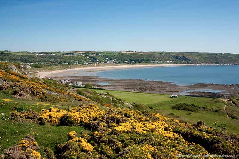
Llangennith Beach
Llangennith Beach is simply the northern part of Rhossili beach, which is accessible via paths through the dunes at Hillend and near the island of Burry Holms.
The Llangennith end of the beach has always attracted a different crowd who come for the surf, which is better at this end than at the southern end as it’s more exposed to the Atlantic westerlies while the Rhossili end is partly sheltered by the headland there.
The island of Burry Holms is well worth exploration at low tide – it enjoys fine views of Rhossili beach and around the corner to the north-west corner of Gower. It is the site of an Iron Age hillfort, and there are also scant remains of what is believed to be a church on the island.
Blue Pool Bay
Beyond Burry Holms, a path continues north-eastwards through marram grasses and dunes, towards Broughton Bay. At high tide, you’d probably miss it altogether with the sand submerged, and there’s no clearly defined path, just a steep slope down. But there is a beach here, and in the north corner, is the perfect rockpool.
This is the handiwork of Mother Nature, a roughly rectangular hole has been eroded in the rock, and it’s nearly always full of seawater. It’s a very secluded spot, and this natural rockpool an amazing place for a dip. It also gives the small beach its name.
Broughton Bay

Broughton Bay, the next beach on our journey, is a vast swathe of sand which links to both Blue Pool Bay and its other neighbour, Whiteford Sands, at low tide.
Broughton Bay has always had a wild, faraway feel. If you’re not staying at one of the two caravan parks near the beach, parking is very limited, and the swirling currents (the beach is close to the Loughor estuary) rule out swimming – these factors combine to deter many visitors, but it’s an inspiring place for a walk, whether in summer or on a sunny winter afternoon.
Whiteford Sands

The last, most northerly beach on Gower is Whiteford Sands (pronounced ‘Witford’). There’s no car park here either – you have to walk down from the nearby village of Llanmadoc to reach it.
Yet it still attracts a faithful few.
The beach itself is around two miles long, backed by dunes and a plantation of pine trees. If you want peace and quiet, this is the place to come. But don’t think you’re seeing things if you think you spot a few figures approaching from the Loughor estuary – they’ll almost certainly have made the long journey across the shifting tidal sands to Whiteford Lighthouse, a disused, cast-iron remnant that still stands sentinel out on its own, where the estuary meets the sea. We haven’t been out there, but know it makes a dramatic photograph subject.